In retrospect, the view from our camping spot below the redwall on the New Hance trail was the best of all the other options we had. Higher up the trail enters a narrow gully and the field of view is significantly narrower.
View from Camp
It rained at night. A steady moderate rain that got the dirt soaked really well. We waited for it to ease off before breaking camp and continuing up trail to the rim road 3500 ft. above.
Continuing along the Colorado River the trail first follows the rim of the Seventyfive Mile Creek and then drops in to return to the river. Seventyfive Mile Creek creates a fantastic slot canyon, cutting through striped layers of sedimentary rock.
Seventyfive Mile CreekKai at Seventyfive Mile Creek
Next Is Papago Creek. There is another steep cliff area along the river requiring climbing high up to get around it. There is a short class 3 climb made interesting when carrying a heavy pack. The last beach along the river is at Hance Rapid.
View from Hance Beach
We filled up with Water for the night and made our way up the New Hance trail. We found a nice camping spot about 1500 ft up from the river.
The hike down river from Palisade Creek is somewhat uneventful until one hits Cardenas Creek, but views of the river are fantastic. From there the trail climbs steeply bypassing an area where the river is protected by sheer cliffs and drops back to the river at Escalante Creek.
Kai
MeThe Colorado River from the ridge north of Escalante Creek
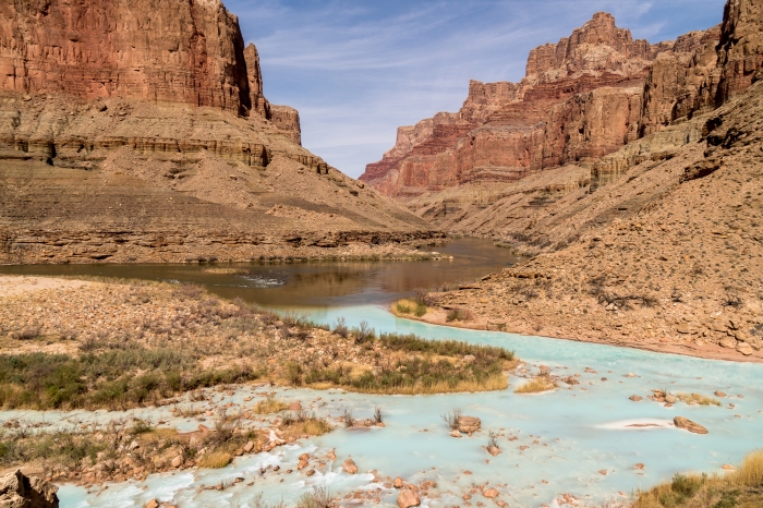
It is 6 miles from the Palisade Creek to the confluence of the Colorado River and the Little Colorado River. The trail travels up and down on cliffs with great views along the river. Except for the The Palisade Creek (at the beginning) and the Confluence (at the end), there is only one beach with access to the river about 1/4 of a mile before the Confluence. It seems to be a good place for hikers wishing to camp close to the Confluence, as there is no camping at the Confluence.
The Little Colorado River water are heavy with sediments and look turquoise compare to the blue-green water of the Colorado River. I understand that sometime the Colorado River water itself is heavy with sediments, but that is not the case today.
Little Colorado River (near), Colorado River (Beyond)
There were several a groups of rafters at the time, the rafts are visible in this image, but they are so small that it is hard to see giving an interesting scale.
Kai and I started down the Tanner trail. Finding the beginning of the trail at Lipan Point was not easy, It seems to start about 100 yards before the parking and there is no sign or anything that marks it. For the first mile or so there was significant of snow on the trail which was a challenge, but after that it was smooth going.
I stopped for lunch at the top of the red wall just before the trail turns and start a steep descent. The view was exceptional
View from the Lookout Point at the Top of the Red Wall
From Tanner Beach we continued up the Colorado river to Palisade Beach where we spent the night.
The Colorado River Between Tanner Beach and the Palisade BeachThe Colorado at Palisade Rapid
Continuing along the Tonto towards Hermit Creek I realized that that entire section is particularly interesting as the trail goes very close to the edge offering great view of the river.
We finished the trip by climbing the 3600 ft back to the rim, which by itself is a very scenic trail.
09 MARCH 2017
I Am writing the date on all the entries from this trip since I am posting by email, so the system will erroneously think they were all created the same day. The day I finally get internet connection.
Today we finally hit Slate Creek, not name after a gem. From there it was about 6 miles to Boucher Creek and a couple more to our camp. Camp is at a spot that I declared to be the best view in the Grand Canyon. There is clear view of the river in both direction with particular good looking cliffs as decision. This is not the first spot to get this designation. I guess the Grand Canyon is do scenic that it is just to difficult to pick one best spot.
I also looked back at some of my earlier posts and noticed how much the weather had warmed up. We were really lucky.
07 MARCH 2017
Today we crossed Serpentine and Ruby creeks and at camp just before the trail turns to cross Turquoise creek. Straight line the distance is not much, but the Tonto trail seems to spend more time going back and forth than forward
08 MARCH 2017
This is day 2 of the section known as the gems along the Tonto trail. Sapphire creek had a good flow of clean water and that is where we fill up for the day. Turquoise had some water in standing pools and Agate had none.
The best view was right after Agate where the trail gets very close to the edge of the cliff right above the river. It gave me an impression that I could throw a rock and hit the water. I tried, it didn’t.
We ate camping tonight on the plateau a couple of trail miles west of Slate Creek.
The Liberty Jeep bounced around, but in the experienced hand of our driver Tim Wilson had little difficulty getting us to the South Bass trailhead.
We met Tim at 7:30 for the ride, and it took 2 hours to drive from the wilderness office to the trailhead. A 2 women group joined us for the ride, but even though we had similar itineraries, we never saw them once we started to hike.
The South Bass trail was in good shape and we made good time to the junction with the Tonto. A group of 3 hikers was there on their way to the trailhead after finishing the route. They reported that there is water available in all the side canyons. In South Bass we needed to hike about a quarter of a mile towards the river to find water pools.
Continuing towards Serpentine Creek we made camp on the plateau at a spot with great view into the river in both directions